CURRENT, HIGH-RES AERIAL IMAGERY ON DEMAND

Keep your projects moving forward, even when you can’t be on site. Fill out the form to get access today to your desired location.

17 FEBRUARY 2020, MELBOURNE, VIC

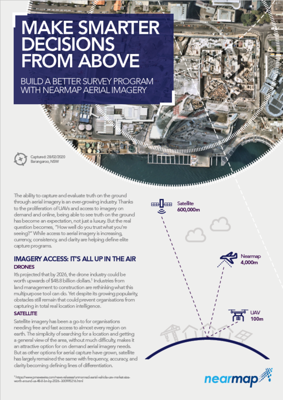
MAKE SMARTER, MORE INFORMED DECISIONS FROM ABOVE

  When somebody rings up requesting a quote, I access Nearmap to get an understanding of the existing site and its surrounds. I’ll refer to the relevant planning regulations to gauge requirements and then have a clear picture of what needs to be done without even leaving my desk.  

— Simon Smith, Director, Absolute Building Consultancy


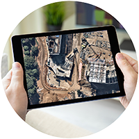
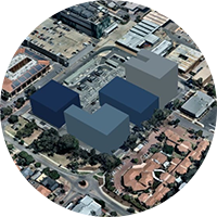
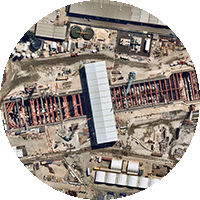
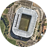
Access to your site may be limited these days, but that shouldn’t stop you from developing, planning and communicating project objectives with HD aerial content. Leverage Nearmap’s high-resolution aerial content to make smarter, more informed decisions at each stage of the project development lifecycle while working remotely.


MAINTAIN BUSINESS CONTINUITY. HIGH-RES IMAGERY KEEPS YOU ON TOP

plan-assess-risk-circle.png
EVALUATE
Evaluate potential properties for purchase and creation of assets.

nm-arcgis-marketplace-logo.png
ASSESS FEASIBILITY
Understand the economic, environmental, infrastructural, and design feasibility of a site.

buy-in-circle.png
DESIGN
Design the asset. Overlay your design on real-world imagery and visualise in both 2D and 3D.

buy-in-circle.png
TENDER
Present a competitive bid or tender. Create an accurate, compelling application with beautiful imagery that’s up to date.

plan-assess-risk-circle.png
BUILD
Consult frequently updated imagery to allow for iterative design and planning as the project evolves.

plan-assess-risk-circle.png
MAINTAIN
Maintain buildings, adhere to environmental standards, detect weather- or human-inflicted damage, estimate repairs, design new infrastructure.


Nearmap

DEPENDABLE LOCATION CONTENT IS KEY

Go beyond satellite and UAV, get full-scale aerial surveys with real location intelligence to help you optimise productivity. Learn more about how adding in Nearmap's product portfolio--3D, vertical, oblique, and panorama--can be a perfect complement to your current imagery library.

Nearmap

SMARTER DECISIONS FROM ABOVE: LEARN HOW TO OPTIMIZE AERIAL AND DRONE SURVEY PROGRAMS

Are you ready to build a better aerial imagery capture program? Using intelligent aerial data helps you make profitable business decisions. In this webinar you'll discover how adding in Nearmap's product portfolio--3D, vertical, oblique, and panorama--can be a perfect complement to your current imagery library.

Go beyond satellite and UAV, get full-scale aerial surveillance with real location intelligence to help you optimize productivity.

Thursday 30 April, 10am (AEST)

COMPATIBLE WITH

Nearmap

Excepteur sint occaecat cupidatat non proident

Lorem ipsum dolor sit amet, consectetur adipiscing elit, sed do eiusmod tempor incididunt ut labore et dolore magna aliqua. Ut enim ad minim veniam.

Excepteur sint occaecat cupidatat non proident

Lorem ipsum dolor sit amet, consectetur adipiscing elit, sed do eiusmod tempor incididunt ut labore et dolore magna aliqua. Ut enim ad minim veniam.

Excepteur sint occaecat cupidatat non proident

Lorem ipsum dolor sit amet, consectetur adipiscing elit, sed do eiusmod tempor incididunt ut labore et dolore magna aliqua. Ut enim ad minim veniam.

image

Lorem ipsum dolor

Lorem ipsum dolor sit amet, consectetur adipiscing elit, sed do eiusmod tempor incididunt ut labore et dolore magna aliqua. Ut enim ad minim veniam.

Lorem ipsum dolor

Lorem ipsum dolor sit amet, consectetur adipiscing elit, sed do eiusmod tempor incididunt ut labore et dolore magna aliqua. Ut enim ad minim veniam.

Lorem ipsum dolor

Lorem ipsum dolor sit amet, consectetur adipiscing elit, sed do eiusmod tempor incididunt ut labore et dolore magna aliqua. Ut enim ad minim veniam.

Lorem ipsum dolor

Lorem ipsum dolor sit amet, consectetur adipiscing elit, sed do eiusmod tempor incididunt ut labore et dolore magna aliqua. Ut enim ad minim veniam.

Excepteur sint occaecat cupidatat non proident

Lorem ipsum dolor sit amet, consectetur adipiscing elit, sed do eiusmod tempor incididunt ut labore et dolore magna aliqua. Ut enim ad minim veniam.

image

Lorem ipsum dolor sit amet, consectetur adipiscing elit, sed do eiusmod tempor incididunt ut labore et dolore magna aliqua. Ut enim ad minim veniam.

plan-assess-risk-circle.png
EVALUATE
Evaluate potential properties for purchase and creation of assets.

nm-arcgis-marketplace-logo.png
ASSESS FEASIBILITY
Understand the economic, environmental, infrastructural, and design feasibility of a site.

buy-in-circle.png
DESIGN
Design the asset. Overlay your design on real-world imagery and visualise in both 2D and 3D.

buy-in-circle.png
TENDER
Present a competitive bid or tender. Create an accurate, compelling application with beautiful imagery that’s up to date.

plan-assess-risk-circle.png
BUILD
Consult frequently updated imagery to allow for iterative design and planning as the project evolves.

plan-assess-risk-circle.png
MAINTAIN
Maintain buildings, adhere to environmental standards, detect weather- or human-inflicted damage, estimate repairs, design new infrastructure.

Level 4, Tower One
100 Barangaroo Avenue
Barangaroo, NSW 2000
☎ 1800 632 762


Privacy Policy | Terms of Use | Contact Us